


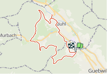
Parking au bout de la rue de l'Ermite - Rect.Rouge Blanc Rouge puis rond jaune Hochkopf-Pont Barnabé-Rond bleu vers Col du Schrangen puis triangle rouge vers Buhl et retour par Hugstein

patrickbeyrath
User

Length
9.1 km

Max alt
516 m

Uphill gradient
355 m
Km-Effort
13.8 km

Min alt
325 m

Downhill gradient
355 m
Boucle
Yes
Creation date :
2018-10-13 05:52:30.14
Updated on :
2018-10-13 05:52:30.152
2h58
Difficulty : Medium

FREE GPS app for hiking
 SityTrail
IGN / Geographical institutes
SityTrail Plus
The world is yours!
About
Trail Walking of 9.1 km to be discovered at Grand Est, Haut-Rhin, Guebwiller. This trail is proposed by patrickbeyrath.
Positioning
Country:
France
Region :
Grand Est
Department/Province :
Haut-Rhin
Municipality :
Guebwiller
Location:
Unknown
Start:(Dec)
Start:(UTM)
365289 ; 5308616 (32T) N.
Comments