


Eyne,col de Nuria,pic d'Eyne,Torre d'Eyne,Eyne.

Machaon6
User
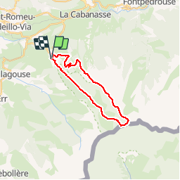

Length
24 km

Max alt
2810 m

Uphill gradient
1437 m
Km-Effort
43 km

Min alt
1584 m

Downhill gradient
1437 m
Boucle
Yes
Creation date :
2018-01-11 00:00:00.0
Updated on :
2018-01-11 00:00:00.0
8h44
Difficulty : Very difficult

FREE GPS app for hiking
 SityTrail
IGN / Geographical institutes
SityTrail Plus
The world is yours!
About
Trail Walking of 24 km to be discovered at Occitania, Pyrénées-Orientales, Eyne. This trail is proposed by Machaon6.
Description
Départ parking de la réserve-1600m
Photos


Positioning
Country:
France
Region :
Occitania
Department/Province :
Pyrénées-Orientales
Municipality :
Eyne
Location:
Unknown
Start:(Dec)
Start:(UTM)
424505 ; 4702335 (31T) N.
Comments
très pratique