


66 PERPIGNAN, Serrat d'en Vaquer, quartier des aviateurs, Mailloles

jeff66
User
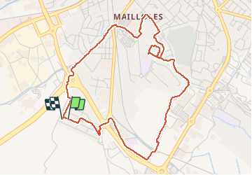


56m
Difficulty : Easy

FREE GPS app for hiking
 SityTrail
IGN / Geographical institutes
SityTrail Plus
The world is yours!
About
Trail Walking of 5.6 km to be discovered at Occitania, Pyrénées-Orientales, Perpignan. This trail is proposed by jeff66.
Description
66 PERPIGNAN, rue henric ARAGON, rues de l'abbé Breuil - anny de Pous, passage JV Coll-Escluse, av. V.Dalbiez, mas jean, villa St François, cours Maintenon. Aqueduc Les arcades, canal de Perpignan, av. Nungesser et Coli, rue Louis Bleriot, centre commercial E.Leclerc, chemin de Ste Barbe - CR29, rues Anny de Pous et Enric Aragon
Photos


Positioning
Comments