


Xxx

jeff66
User
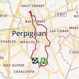

Length
15.1 km

Max alt
67 m

Uphill gradient
140 m
Km-Effort
16.9 km

Min alt
24 m

Downhill gradient
140 m
Boucle
Yes
Creation date :
2016-03-09 00:00:00.0
Updated on :
2016-03-09 00:00:00.0
2h26
Difficulty : Medium

FREE GPS app for hiking
 SityTrail
IGN / Geographical institutes
SityTrail Plus
The world is yours!
About
Trail Walking of 15.1 km to be discovered at Occitania, Pyrénées-Orientales, Perpignan. This trail is proposed by jeff66.
Description
Xxx
Photos


26 photos in total. Please click on a photo to see them all in the gallery.
Positioning
Country:
France
Region :
Occitania
Department/Province :
Pyrénées-Orientales
Municipality :
Perpignan
Location:
Unknown
Start:(Dec)
Start:(UTM)
491480 ; 4723854 (31T) N.
Comments