


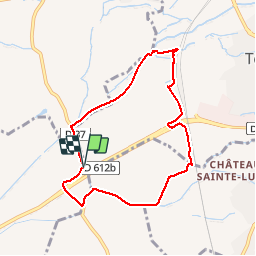
66 TOULOUGES, promenade entre la Basse, la L.G.V. Et le canal de Perpignan

jeff66
User


1h22
Difficulty : Easy

FREE GPS app for hiking
 SityTrail
IGN / Geographical institutes
SityTrail Plus
The world is yours!
About
Trail Walking of 7.8 km to be discovered at Occitania, Pyrénées-Orientales, Thuir. This trail is proposed by jeff66.
Description
66 TOULOUGES, promenade entre la Basse, la L.G.V. Et le canal de Perpignan, mas Santa Teresa, mas de l'arbre,
Mas de Rieres, Colomina d'en Quaranta, mas Delrieux, château Lauriga, emprunter la Rd37, passer sous la RD612a
Positioning
Comments