Trail Mountain bike Saint-Pierre-d'Argençon - HA J3 long - Photo
 thierryd
thierryd

User

© OpenStreetMap contributors
Length
Length
34 km
Max alt
Max alt
903 m
Uphill gradient
Uphill gradient
544 m
Km-Effort
Km-Effort  
42 km
Min alt
Min alt
616 m
Downhill gradient
Downhill gradient
656 m
Boucle
Boucle
No
Creation date :
2016-03-28 00:00:00.0
Updated on :
2016-03-28 00:00:00.0

(4 Reviews)

Mountain bike
Mountain bike
2h45
Difficulty : Unknown

Scan this QR Code to open this trail in the SityTrail application

FREE GPS app for hiking

Logo SityTrail SityTrail

IGN / Geographical institutes

Download SityTrail from the App Store Download SityTrail from Google Play

Logo SityTrail SityTrail World

The world is yours!

Download SityTrail from the App Store Download SityTrail from Google Play Download SityTrail on Huawei AppGallery

About

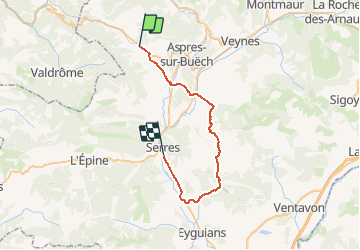
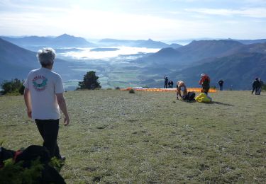
Trail Mountain bike of 34 km to be discovered at Provence-Alpes-Côte d'Azur, Hautes-Alpes, Saint-Pierre-d'Argençon. This trail is proposed by thierryd.

Elevation profile

Positioning

Country:
France
Region :
Provence-Alpes-Côte d'Azur
Department/Province :
Hautes-Alpes
Municipality :
Saint-Pierre-d'Argençon
Location:
Unknown
Start:(UTM)
713350 ; 4934222 (31T) N.

Comments

Please log in to post a review or rate the element


valable


Trop bon les gorges de Riou


splendide, varié, à ne manquer sous aucun prétexte. un grand merci au créateur


Trails nearby

Trail Walking La Faurie - R40   Les Marmites du Diable - Photo
Walking
GUIDE+

Walking

Medium
(6)
La Faurie, Provence-Alpes-Côte d'Azur, Hautes-Alpes, France
5.9 km | 10.4 km-effort
2h 7min
Yes
Trail Walking Aspres-sur-Buëch - R42   La Longeagne - Photo
Walking
GUIDE+

Walking

Very easy
(1)
Aspres-sur-Buëch, Provence-Alpes-Côte d'Azur, Hautes-Alpes, France
7.1 km | 11.2 km-effort
2h 23min
Yes
Trail Walking La Bâtie-des-Fonds - cretes des sources de la Drome - Photo
Walking
gibello

Walking

Easy
La Bâtie-des-Fonds, Auvergne-Rhône-Alpes, Drôme, France
10.8 km | 17.8 km-effort
4h 46min
Yes
Trail Walking La Haute-Beaume - R50 Le Luzet - Photo
Walking
GUIDE+

Walking

Medium
La Haute-Beaume, Provence-Alpes-Côte d'Azur, Hautes-Alpes, France
8.4 km | 14.8 km-effort
3h 0min
Yes
Trail Walking La Haute-Beaume - R49  La Haute Beaume - Photo
Walking
GUIDE+

Walking

Easy
La Haute-Beaume, Provence-Alpes-Côte d'Azur, Hautes-Alpes, France
9.3 km | 14.8 km-effort
2h 30min
Yes
Trail Walking La Bâtie-des-Fonds - Roc De La Tour - Source de la Drôme - Photo
Walking
PapouBertrand

Walking

Medium
La Bâtie-des-Fonds, Auvergne-Rhône-Alpes, Drôme, France
12.5 km | 21 km-effort
5h 4min
Yes
Trail Walking La Beaume - Ranc de Chamoussière - Crête de la Longeagne - Photo
Walking
PapouBertrand

Walking

Very difficult
La Beaume, Provence-Alpes-Côte d'Azur, Hautes-Alpes, France
12.9 km | 23 km-effort
5h 17min
Yes
Trail Walking Aspres-sur-Buëch - Montagne Saint-Apôtre  - Photo
Walking
PapouBertrand

Walking

Very difficult
Aspres-sur-Buëch, Provence-Alpes-Côte d'Azur, Hautes-Alpes, France
9.9 km | 19.4 km-effort
5h 17min
Yes
Trail Walking La Piarre - la Piarre et valdrôme - Photo
Walking
ericlong

Walking

Very easy
La Piarre, Provence-Alpes-Côte d'Azur, Hautes-Alpes, France
4 km | 9.8 km-effort
5h 57min
No


Close
My subscriptions