La Rhune au départ d'Olhette

claudel
User
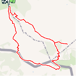

Length
11.9 km

Max alt
895 m

Uphill gradient
838 m
Km-Effort
23 km

Min alt
95 m

Downhill gradient
831 m
Boucle
Yes
Creation date :
2016-04-01 00:00:00.0
Updated on :
2016-04-01 00:00:00.0
4h39
Difficulty : Unknown

FREE GPS app for hiking
 SityTrail
IGN / Geographical institutes
SityTrail Plus
The world is yours!
About
Trail Walking of 11.9 km to be discovered at New Aquitaine, Pyrénées-Atlantiques, Urrugne. This trail is proposed by claudel.
Positioning
Country:
France
Region :
New Aquitaine
Department/Province :
Pyrénées-Atlantiques
Municipality :
Urrugne
Location:
Unknown
Start:(Dec)
Start:(UTM)
608614 ; 4798560 (30T) N.
Comments