


Mont Baïgura

claudel
User
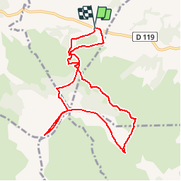

Length
9.6 km

Max alt
885 m

Uphill gradient
629 m
Km-Effort
17.9 km

Min alt
294 m

Downhill gradient
625 m
Boucle
Yes
Creation date :
2016-04-01 00:00:00.0
Updated on :
2016-04-01 00:00:00.0
3h42
Difficulty : Unknown

FREE GPS app for hiking
 SityTrail
IGN / Geographical institutes
SityTrail Plus
The world is yours!
About
Trail Walking of 9.6 km to be discovered at New Aquitaine, Pyrénées-Atlantiques, Mendionde. This trail is proposed by claudel.
Positioning
Country:
France
Region :
New Aquitaine
Department/Province :
Pyrénées-Atlantiques
Municipality :
Mendionde
Location:
Unknown
Start:(Dec)
Start:(UTM)
639286 ; 4796569 (30T) N.
Comments
Super promenade mais peut-être à faire dans l'autre sens.