Trail Touring skiing Névache - Ricou descente depuis Gardioles - Photo

Ricou descente depuis Gardioles

© OpenStreetMap contributors
Length
Length
2.8 km
Max alt
Max alt
2664 m
Uphill gradient
Uphill gradient
0 m
Km-Effort
Km-Effort  
4.6 km
Min alt
Min alt
2111 m
Downhill gradient
Downhill gradient
546 m
Boucle
Boucle
No
Creation date :
2016-04-08 00:00:00.0
Updated on :
2019-08-28 14:45:35.892

(0 Reviews)

Touring skiing
Touring skiing
37m
Difficulty : Medium

Scan this QR Code to open this trail in the SityTrail application

FREE GPS app for hiking

Logo SityTrail SityTrail

IGN / Geographical institutes

Download SityTrail from the App Store Download SityTrail from Google Play

Logo SityTrail SityTrail World

The world is yours!

Download SityTrail from the App Store Download SityTrail from Google Play Download SityTrail on Huawei AppGallery

About

Trail Touring skiing of 2.8 km to be discovered at Provence-Alpes-Côte d'Azur, Hautes-Alpes, Névache. This trail is proposed by motardes04.

Description

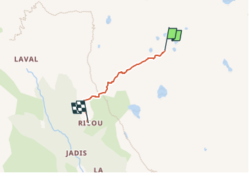
Ski de rando - CAF. 3/4/2016. Neige pourrie, merci le sirocco, un très léger regel de surface sur une neige très lourde. Merci au gardien du refuge Ricou qui a tracé pour nous, car sinon, difficile d'éviter les zones déneigées.

Où, avec une crève carabinée, je me souviens que le chasse neige est mon ami ...

Elevation profile

Positioning

Country:
France
Region :
Provence-Alpes-Côte d'Azur
Department/Province :
Hautes-Alpes
Municipality :
Névache
Location:
Unknown
Start:(UTM)
308128 ; 4992410 (32T) N.

Trails nearby

Trail Walking Névache - Lac Vert.Vallée Etroite.(27-09-17) - Photo
Walking
Dervalmarc

Walking

Very easy
(1)
Névache, Provence-Alpes-Côte d'Azur, Hautes-Alpes, France
4.2 km | 5.9 km-effort
1h 19min
Yes
Trail Walking Névache - les granges de la vallée étroite au refuge du Mont Thabor - Photo
Walking
reneperrin

Walking

Easy
(1)
Névache, Provence-Alpes-Côte d'Azur, Hautes-Alpes, France
8.6 km | 16.2 km-effort
3h 44min
No
Trail Walking Névache - Briançonnais Lac du Serpent - Photo
Walking
Orcal37

Walking

Medium
(2)
Névache, Provence-Alpes-Côte d'Azur, Hautes-Alpes, France
10 km | 18 km-effort
3h 10min
Yes
Trail Walking Névache - Col du Chardonnet - Névache - Photo
Walking
tracegps

Walking

Medium
(3)
Névache, Provence-Alpes-Côte d'Azur, Hautes-Alpes, France
12.3 km | 23 km-effort
4h 0min
Yes
Trail Mountain bike Névache - Tour des Rois Mages en VTT - Névache - Photo
Mountain bike
tracegps

Mountain bike

Difficult
(2)
Névache, Provence-Alpes-Côte d'Azur, Hautes-Alpes, France
35 km | 55 km-effort
5h 0min
Yes
Trail Walking Névache - Via Alpina - R127: Névache > Le Monêtier-les-Bains - Photo
Walking
tracegps

Walking

Difficult
(1)
Névache, Provence-Alpes-Côte d'Azur, Hautes-Alpes, France
15.5 km | 28 km-effort
5h 0min
No
Trail Walking Névache - la roche du Chardonnet - Photo
Walking
GUIDE
amiral13

Walking

Medium
Névache, Provence-Alpes-Côte d'Azur, Hautes-Alpes, France
16.6 km | 29 km-effort
7h 26min
Yes
Trail Walking Névache - le Mont Thabor - Photo
Walking
GUIDE
amiral13

Walking

Difficult
Névache, Provence-Alpes-Côte d'Azur, Hautes-Alpes, France
19.9 km | 40 km-effort
8h 44min
Yes
Trail Walking Névache - Lacs Laramon et Serpent - Photo
Walking
neoroll44

Walking

Medium
(2)
Névache, Provence-Alpes-Côte d'Azur, Hautes-Alpes, France
10.4 km | 21 km-effort
6h 0min
Yes


Close
My subscriptions