


pont du casse - bajamont - coteaux nord-ouest

mapomme
User
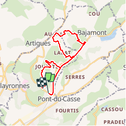

Length
14.1 km

Max alt
200 m

Uphill gradient
308 m
Km-Effort
18.2 km

Min alt
66 m

Downhill gradient
320 m
Boucle
No
Creation date :
2016-04-13 00:00:00.0
Updated on :
2016-04-13 00:00:00.0
1h47
Difficulty : Easy

FREE GPS app for hiking
 SityTrail
IGN / Geographical institutes
SityTrail Plus
The world is yours!
About
Trail Mountain bike of 14.1 km to be discovered at New Aquitaine, Lot-et-Garonne, Pont-du-Casse. This trail is proposed by mapomme.
Description
Très belle boucle en sous bois et flancs de coteaux. Terrain gras
Positioning
Country:
France
Region :
New Aquitaine
Department/Province :
Lot-et-Garonne
Municipality :
Pont-du-Casse
Location:
Unknown
Start:(Dec)
Start:(UTM)
314001 ; 4900926 (31T) N.
Comments