


Wildenstein-Abri du Tal- Abri des Pionniers - Abri Bockloch et retour

patrickbeyrath
User
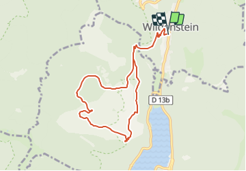

Length
8.6 km

Max alt
957 m

Uphill gradient
499 m
Km-Effort
15.2 km

Min alt
566 m

Downhill gradient
498 m
Boucle
Yes
Creation date :
2018-10-13 05:52:26.112
Updated on :
2018-10-13 05:52:26.133
3h14
Difficulty : Medium

FREE GPS app for hiking
 SityTrail
IGN / Geographical institutes
SityTrail Plus
The world is yours!
About
Trail Walking of 8.6 km to be discovered at Grand Est, Haut-Rhin, Wildenstein. This trail is proposed by patrickbeyrath.
Positioning
Country:
France
Region :
Grand Est
Department/Province :
Haut-Rhin
Municipality :
Wildenstein
Location:
Unknown
Start:(Dec)
Start:(UTM)
347815 ; 5315741 (32T) N.
Comments