Trail Walking Ingré - Ingré - Photo
 Mecki
Mecki

User

© OpenStreetMap contributors
Length
Length
24 km
Max alt
Max alt
133 m
Uphill gradient
Uphill gradient
160 m
Km-Effort
Km-Effort  
26 km
Min alt
Min alt
101 m
Downhill gradient
Downhill gradient
161 m
Boucle
Boucle
Yes
Creation date :
2016-04-26 00:00:00.0
Updated on :
2016-04-26 00:00:00.0

(0 Reviews)

Walking
Walking
4h44
Difficulty : Medium

Scan this QR Code to open this trail in the SityTrail application

FREE GPS app for hiking

Logo SityTrail SityTrail

IGN / Geographical institutes

Download SityTrail from the App Store Download SityTrail from Google Play

Logo SityTrail SityTrail World

The world is yours!

Download SityTrail from the App Store Download SityTrail from Google Play Download SityTrail on Huawei AppGallery

About

Trail Walking of 24 km to be discovered at Centre-Loire Valley, Loiret, Ingré. This trail is proposed by Mecki.

Elevation profile

Photos

Points of interest

Point of interest Ormes - Jacinthe - Photo
Mecki
ORMES 

Positioning

Country:
France
Region :
Centre-Loire Valley
Department/Province :
Loiret
Municipality :
Ingré
Location:
Unknown
Start:(UTM)
413092 ; 5307725 (31T) N.

Trails nearby

Trail Mountain bike Saint-Jean-de-la-Ruelle - Orleans-Jargeau-Orleans-60km-3h40 - Photo
Mountain bike
delalex

Mountain bike

Medium
Saint-Jean-de-la-Ruelle, Centre-Loire Valley, Loiret, France
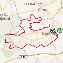
52 km | 57 km-effort
3h 40min
Yes
Trail Running Saint-Pryvé-Saint-Mesmin - Olivet Découverte  - Photo
Running
zazie

Running

Easy
Saint-Pryvé-Saint-Mesmin, Centre-Loire Valley, Loiret, France
13 km | 14 km-effort
1h 10min
Yes
Trail Mountain bike Saint-Jean-de-la-Ruelle - Orleans-Meung-sur-Loire -39.2km-2h30 - Photo
Mountain bike
delalex

Mountain bike

Medium
Saint-Jean-de-la-Ruelle, Centre-Loire Valley, Loiret, France
39 km | 43 km-effort
2h 28min
Yes
Trail Nordic walking Saran - Forêt orléans - Saran - Photo
Nordic walking
Robert Trebor

Nordic walking

Very easy
Saran, Centre-Loire Valley, Loiret, France
8.9 km | 9.7 km-effort
1h 40min
Yes
Trail Road bike Orléans - Orleans-Beaugency - Photo
Road bike
benoit.baillot

Road bike

Difficult
Orléans, Centre-Loire Valley, Loiret, France
33 km | 35 km-effort
4h 26min
No
Trail Walking Olivet - bord du loiret - Photo
Walking
cristinette

Walking

Easy
Olivet, Centre-Loire Valley, Loiret, France
11.6 km | 12.7 km-effort
2h 52min
Yes
Trail Walking Saran - Saran Marche du Givre - Photo
Walking
Rovo

Walking

Very easy
Saran, Centre-Loire Valley, Loiret, France
12.3 km | 13.5 km-effort
1h 47min
No
Trail Walking Orléans - d'Orléans à Blois - Photo
Walking
wallander76

Walking

Very difficult
Orléans, Centre-Loire Valley, Loiret, France
63 km | 68 km-effort
15h 4min
No
Trail Other activity Orléans - D'Orléans à Blois - Photo
Other activity
wallander76

Other activity

Difficult
Orléans, Centre-Loire Valley, Loiret, France
67 km | 72 km-effort
10h 0min
No


Close
My subscriptions