


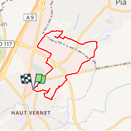
66 PERPIGNAN Nord, hôpital,

jeff66
User

Length
8.1 km

Max alt
34 m

Uphill gradient
36 m
Km-Effort
8.6 km

Min alt
19 m

Downhill gradient
36 m
Boucle
Yes
Creation date :
2016-05-13 00:00:00.0
Updated on :
2016-05-13 00:00:00.0
1h25
Difficulty : Easy

FREE GPS app for hiking
 SityTrail
IGN / Geographical institutes
SityTrail Plus
The world is yours!
About
Trail Walking of 8.1 km to be discovered at Occitania, Pyrénées-Orientales, Perpignan. This trail is proposed by jeff66.
Description
66 PERPIGNAN Nord, hôpital,
CTM, plaine des jeux A.Sanac, RD1 vers BOMPAS, ZI POLYGONE NORD, PIA
Positioning
Country:
France
Region :
Occitania
Department/Province :
Pyrénées-Orientales
Municipality :
Perpignan
Location:
Unknown
Start:(Dec)
Start:(UTM)
490973 ; 4730122 (31T) N.
Comments