Trail Walking Saint-Quirin - Le circuit des 7 roses - Photo

Le circuit des 7 roses

© OpenStreetMap contributors
Length
Length
17 km
Max alt
Max alt
480 m
Uphill gradient
Uphill gradient
467 m
Km-Effort
Km-Effort  
23 km
Min alt
Min alt
286 m
Downhill gradient
Downhill gradient
467 m
Boucle
Boucle
Yes
Creation date :
2016-05-05 00:00:00.0
Updated on :
2016-05-05 00:00:00.0

(2 Reviews)

Walking
Walking
5h03
Difficulty : Medium

Scan this QR Code to open this trail in the SityTrail application

FREE GPS app for hiking

Logo SityTrail SityTrail

IGN / Geographical institutes

Download SityTrail from the App Store Download SityTrail from Google Play

Logo SityTrail SityTrail World

The world is yours!

Download SityTrail from the App Store Download SityTrail from Google Play Download SityTrail on Huawei AppGallery

About

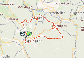
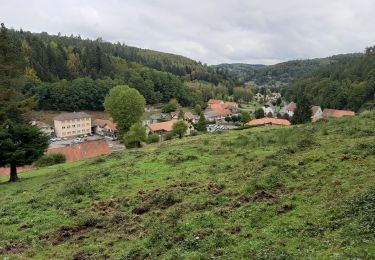
Trail Walking of 17 km to be discovered at Grand Est, Moselle, Saint-Quirin. This trail is proposed by VacheKiri67.

Description

Faite le 05/05/2016 avec notre fils de 11 ans. D'après "Passion Vosges - Autour des abbayes du massif vosgien" N°4 : L'ancien prieuré de Saint-Quirin, paroisse aux sept sanctuaires. Durée indiquée pour le circuit : 5h. Très bon balisage anneau jaune de bout en bout. Itinéraire disponible ici http://www.sitlor.fr/photos/855/855145377_d1.pdf

Elevation profile

Photos

Positioning

Country:
France
Region :
Grand Est
Department/Province :
Moselle
Municipality :
Saint-Quirin
Location:
Unknown
Start:(UTM)
356583 ; 5386043 (32U) N.

Comments

Please log in to post a review or rate the element


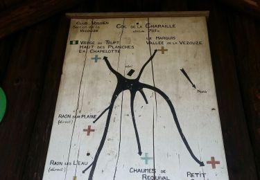
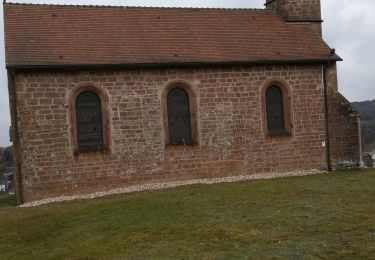
Les roses sont des églises ou des chapelles. Leurs vitraux sont particulièrement beaux et variés. A noter l'excellent balisage du circuit ainsi que la nombreuse présence de tables et de bancs.


Trails nearby

Trail Cycle Abreschviller - Circuit du Donon - Photo
Cycle
tracegps

Cycle

Very difficult
(1)
Abreschviller, Grand Est, Moselle, France
52 km | 67 km-effort
3h 0min
Yes
Trail Mountain bike Abreschviller - sortie VTT du 01092019 Abreschwiller - Photo
Mountain bike
GUIDE
fabwin

Mountain bike

Difficult
Abreschviller, Grand Est, Moselle, France
33 km | 45 km-effort
2h 42min
Yes
Trail Mountain bike Bertrambois - sortie vtt du 20052018 - Photo
Mountain bike
GUIDE
fabwin

Mountain bike

Difficult
Bertrambois, Grand Est, Meurthe-et-Moselle, France
45 km | 58 km-effort
2h 35min
Yes
Trail Walking Abreschviller - Circulaire de la Roche du Diable - Abreschviller - Photo
Walking
xtislair

Walking

Difficult
(1)
Abreschviller, Grand Est, Moselle, France
10.1 km | 14.7 km-effort
3h 20min
Yes
Trail Walking Saint-Quirin - St Quirin et ses 6 roses - Photo
Walking
Bart2015

Walking

Very difficult
Saint-Quirin, Grand Est, Moselle, France
18.7 km | 25 km-effort
5h 41min
Yes
Trail Running Niderhoff - niderhoff  lorquin - Photo
Running
Titinechris

Running

Easy
(1)
Niderhoff, Grand Est, Moselle, France
12.2 km | 14.3 km-effort
2h 0min
Yes
Trail Horseback riding Niderhoff - Parcours cavaliers Equiplaine Niderhoff - Photo
Horseback riding
raline

Horseback riding

Medium
Niderhoff, Grand Est, Moselle, France
27 km | 34 km-effort
6h 1min
Yes
Trail Walking Abreschviller - 20210909_rando_MCA_Abreschwiller_Walscheid - Photo
Walking
nfranche

Walking

Very difficult
Abreschviller, Grand Est, Moselle, France
15.6 km | 24 km-effort
5h 23min
Yes
Trail Walking Saint-Quirin - st Quirin  - Photo
Walking
JJG54

Walking

Medium
Saint-Quirin, Grand Est, Moselle, France
9.9 km | 13.8 km-effort
2h 26min
No


Close
My subscriptions