


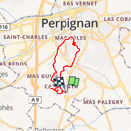
66 PERPIGNAN, mas de Bon secours, le canal, Serat d'en vaquer, Aqueduc, les Arcades, quartier des aviateurs, Mailloles, Calalunya

jeff66
User


1h55
Difficulty : Easy

FREE GPS app for hiking
 SityTrail
IGN / Geographical institutes
SityTrail Plus
The world is yours!
About
Trail Walking of 10.9 km to be discovered at Occitania, Pyrénées-Orientales, Perpignan. This trail is proposed by jeff66.
Description
66 PERPIGNAN, mas de Bon secours, rues de la Bisbal -Benidorm - Gerone, le Canal, centre commercial, Serrat d'en Vaquer, Mas Comté, Aqueduc des Arcades, quartier des aviateurs, Bld Nungesser et Coli, rue L.Bleriot, Ctre Cial Leclerc sud, Chemin de Mailloles, mas Roig, Calalunya, rues de la Seu d'Urgell - de Berga - de Puigcerda - de PortBou - de LLoret del mar - de Sabadell, place de Costa Brava
Positioning
Comments