Trail Mountain bike Montjustin - Liaison VTT Grande Traversée de Vaucluse - Grande Traversée Alpes-Provence - Photo

Liaison VTT Grande Traversée de Vaucluse - Grande Traversée Alpes-Provence

Randonnées de Vélo Loisir Provence GUIDE+

© OpenStreetMap contributors
Length
Length
16.2 km
Max alt
Max alt
677 m
Uphill gradient
Uphill gradient
392 m
Km-Effort
Km-Effort  
21 km
Min alt
Min alt
546 m
Downhill gradient
Downhill gradient
339 m
Boucle
Boucle
No
Signpost
Signpost
Creation date :
2016-06-13 00:00:00.0
Updated on :
2016-06-13 00:00:00.0

(0 Reviews)

Mountain bike
Mountain bike
1h26
Difficulty : Difficult

Scan this QR Code to open this trail in the SityTrail application

FREE GPS app for hiking

Logo SityTrail SityTrail

IGN / Geographical institutes

Download SityTrail from the App Store Download SityTrail from Google Play

Logo SityTrail SityTrail World

The world is yours!

Download SityTrail from the App Store Download SityTrail from Google Play Download SityTrail on Huawei AppGallery

About

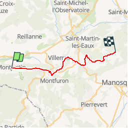
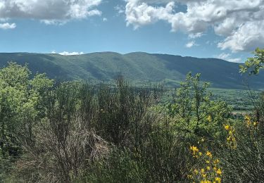
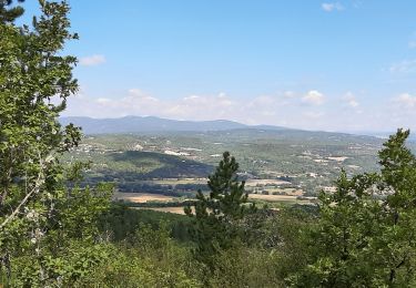
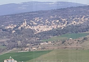
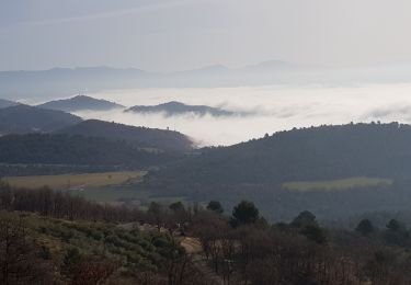
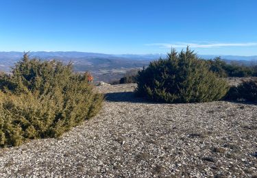
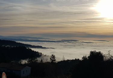
Trail Mountain bike of 16.2 km to be discovered at Provence-Alpes-Côte d'Azur, Alpes-de-Haute-Provence, Montjustin. This trail is proposed by Vélo Loisir Provence.

Description

By a succession of tracks which snake along the rounded ridge and wooded crest of the eastern Luberon, with beautiful views to the north and the south, this link can be taken in both directions: On leaving “La Grande Traversée de Vaucluse” via the Luberon at Manosque or on extending the “La Grande Traversée Alpes-Provence” and “LaTransverdon” across the Luberon.

Elevation profile

Photos

Points of interest

Point of interest Montjustin - 18-00 - Photo
Vélo Loisir Provence
MONTJUSTIN 
Point of interest Montfuron - 18-01 - Photo
Vélo Loisir Provence
MONTFURON 
Point of interest Saint-Martin-les-Eaux - 18-02 - Photo
Vélo Loisir Provence
SAINT-MARTIN-LES-EAUX 

Positioning

Country:
France
Region :
Provence-Alpes-Côte d'Azur
Department/Province :
Alpes-de-Haute-Provence
Municipality :
Montjustin
Location:
Unknown
Start:(UTM)
711876 ; 4858370 (31T) N.

Trails nearby

Trail Walking Reillanne - 2024-03-01 Tour de Reillanne  - Photo
Walking
GUIDE
Kargil

Walking

Difficult
Reillanne, Provence-Alpes-Côte d'Azur, Alpes-de-Haute-Provence, France
17.9 km | 24 km-effort
5h 30min
Yes
Trail Walking Céreste - Colline de la Gardette-Céreste-08-05-23 - Photo
Walking
Christiancordin

Walking

Medium
Céreste, Provence-Alpes-Côte d'Azur, Alpes-de-Haute-Provence, France
8.1 km | 11.6 km-effort
2h 2min
Yes
Trail Walking Céreste - Cereste - Photo
Walking
Christiancordin

Walking

Medium
Céreste, Provence-Alpes-Côte d'Azur, Alpes-de-Haute-Provence, France
7.3 km | 9.1 km-effort
1h 56min
Yes
Trail Walking Vitrolles-en-Luberon - Mascas Mourre negre  - Photo
Walking
GUIDE
antignacs

Walking

Medium
Vitrolles-en-Luberon, Provence-Alpes-Côte d'Azur, Vaucluse, France
25 km | 35 km-effort
7h 1min
Yes
Trail Walking Vitrolles-en-Luberon - vitrolles en Lubéron. aire des mascas - Photo
Walking
Roger

Walking

Medium
Vitrolles-en-Luberon, Provence-Alpes-Côte d'Azur, Vaucluse, France
9.9 km | 16.2 km-effort
3h 19min
Yes
Trail Walking Montfuron - 1Montfuron, Villemus via la Colle et le Moulin. - Photo
Walking
liocol

Walking

Easy
Montfuron, Provence-Alpes-Côte d'Azur, Alpes-de-Haute-Provence, France
7.6 km | 9.9 km-effort
2h 4min
Yes
Trail Walking Montfuron - 1Montfuron, le relais de Villemus - Photo
Walking
liocol

Walking

Medium
Montfuron, Provence-Alpes-Côte d'Azur, Alpes-de-Haute-Provence, France
8 km | 11.2 km-effort
2h 9min
Yes
Trail Walking Céreste - Col des Mascas 84 - Photo
Walking
Dadou 1

Walking

Very easy
Céreste, Provence-Alpes-Côte d'Azur, Alpes-de-Haute-Provence, France
8.3 km | 11.9 km-effort
3h 45min
Yes
Trail Walking Montfuron - Montfuron à Villemus, variante.  - Photo
Walking
liocol

Walking

Easy
(2)
Montfuron, Provence-Alpes-Côte d'Azur, Alpes-de-Haute-Provence, France
7.6 km | 9.8 km-effort
2h 3min
Yes


Close
My subscriptions