


Coudray Salbart 2

olaze
User
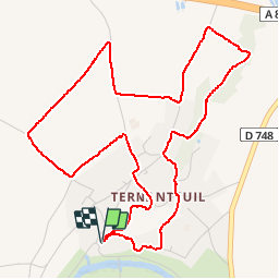

Length
6 km

Max alt
74 m

Uphill gradient
83 m
Km-Effort
7.2 km

Min alt
36 m

Downhill gradient
83 m
Boucle
Yes
Creation date :
2017-05-10 00:00:00.0
Updated on :
2018-08-06 14:49:58.764
1h33
Difficulty : Medium

FREE GPS app for hiking
 SityTrail
IGN / Geographical institutes
SityTrail Plus
The world is yours!
About
Trail Walking of 6 km to be discovered at New Aquitaine, Deux-Sèvres, Échiré. This trail is proposed by olaze.
Description
Variante. Très agréable ballade autour du château et la campagne.
Photos


Positioning
Country:
France
Region :
New Aquitaine
Department/Province :
Deux-Sèvres
Municipality :
Échiré
Location:
Unknown
Start:(Dec)
Start:(UTM)
697713 ; 5142519 (30T) N.
Comments