


Ultra Vanoise

pzellner
User
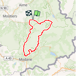

Length
113 km

Max alt
2790 m

Uphill gradient
6258 m
Km-Effort
196 km

Min alt
1408 m

Downhill gradient
6250 m
Boucle
Yes
Creation date :
2016-05-25 00:00:00.0
Updated on :
2016-05-25 00:00:00.0
38h32
Difficulty : Very difficult

FREE GPS app for hiking
 SityTrail
IGN / Geographical institutes
SityTrail Plus
The world is yours!
About
Trail Running of 113 km to be discovered at Auvergne-Rhône-Alpes, Savoy, Champagny-en-Vanoise. This trail is proposed by pzellner.
Positioning
Country:
France
Region :
Auvergne-Rhône-Alpes
Department/Province :
Savoy
Municipality :
Champagny-en-Vanoise
Location:
Unknown
Start:(Dec)
Start:(UTM)
323675 ; 5036463 (32T) N.
Comments