Trail Walking Sus-Saint-Léger - LUCHEUX et sa forêt - Photo
 camino59
camino59

User

© OpenStreetMap contributors
Length
Length
14.8 km
Max alt
Max alt
161 m
Uphill gradient
Uphill gradient
175 m
Km-Effort
Km-Effort  
17.2 km
Min alt
Min alt
80 m
Downhill gradient
Downhill gradient
174 m
Boucle
Boucle
Yes
Creation date :
2016-05-30 00:00:00.0
Updated on :
2016-05-30 00:00:00.0

(0 Reviews)

Walking
Walking
3h49
Difficulty : Easy

Scan this QR Code to open this trail in the SityTrail application

FREE GPS app for hiking

Logo SityTrail SityTrail

IGN / Geographical institutes

Download SityTrail from the App Store Download SityTrail from Google Play

Logo SityTrail SityTrail World

The world is yours!

Download SityTrail from the App Store Download SityTrail from Google Play Download SityTrail on Huawei AppGallery

About

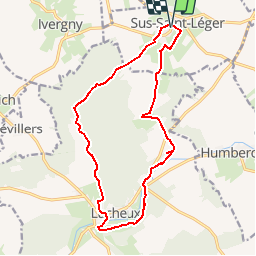
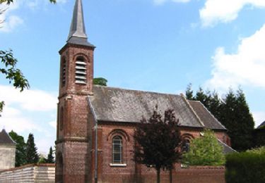
Trail Walking of 14.8 km to be discovered at Hauts-de-France, Pas-de-Calais, Sus-Saint-Léger. This trail is proposed by camino59.

Description

Randonnée au sein de la forêt de Lucheux et le GR 124

Elevation profile

Positioning

Country:
France
Region :
Hauts-de-France
Department/Province :
Pas-de-Calais
Municipality :
Sus-Saint-Léger
Location:
Unknown
Start:(UTM)
459415 ; 5565233 (31U) N.

Trails nearby

Trail Walking Sus-Saint-Léger - Sentier du Petit Dieu - Sus-Saint-Léger - Photo
Walking
tracegps

Walking

Medium
Sus-Saint-Léger, Hauts-de-France, Pas-de-Calais, France
11.8 km | 12.9 km-effort
2h 55min
Yes
Trail Walking Berlencourt-le-Cauroy - Le sentier du loup (Berlencourt-le-cauroy) - Photo
Walking
tracegps

Walking

Difficult
Berlencourt-le-Cauroy, Hauts-de-France, Pas-de-Calais, France
15.2 km | 17.3 km-effort
3h 45min
Yes
Trail Walking Estrée-Wamin - ESTREE-WAMIN (62) - Les Sertelles - Photo
Walking
temmichel

Walking

Difficult
Estrée-Wamin, Hauts-de-France, Pas-de-Calais, France
11.2 km | 13 km-effort
2h 57min
Yes
Trail Walking Canettemont - CANETTEMONT (62) Le chemin de Saint Pol - Photo
Walking
temmichel

Walking

Medium
Canettemont, Hauts-de-France, Pas-de-Calais, France
8.2 km | 8.9 km-effort
2h 1min
Yes
Trail Walking Lucheux - Lucheux - l'allée royale - Photo
Walking
temmichel

Walking

Difficult
Lucheux, Hauts-de-France, Somme, France
10.1 km | 12 km-effort
2h 44min
Yes
Trail Walking Warluzel - Le sentier des deux sources. (Warluzel) - Photo
Walking
tracegps

Walking

Difficult
Warluzel, Hauts-de-France, Pas-de-Calais, France
13.4 km | 15.1 km-effort
3h 19min
Yes
Trail Walking Warluzel - Warluzel 7,7 km - Photo
Walking
Barney62

Walking

Medium
Warluzel, Hauts-de-France, Pas-de-Calais, France
7.7 km | 8.6 km-effort
1h 54min
Yes
Trail Walking Berlencourt-le-Cauroy - Berlencourt/Lucheux 23Kms Dén P 266m - Photo
Walking
alain62rando

Walking

Medium
Berlencourt-le-Cauroy, Hauts-de-France, Pas-de-Calais, France
23 km | 27 km-effort
5h 49min
No
Trail Walking Berlencourt-le-Cauroy - La Cauroy 11.3Kms Dén P 134m - Photo
Walking
alain62rando

Walking

Easy
Berlencourt-le-Cauroy, Hauts-de-France, Pas-de-Calais, France
11.5 km | 13.2 km-effort
2h 54min
Yes


Close
My subscriptions