


2016-06-14 Gap - Barcelonnette 92km

Lucquiaud
User
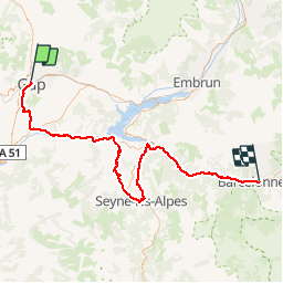

Length
92 km

Max alt
1368 m

Uphill gradient
1919 m
Km-Effort
116 km

Min alt
601 m

Downhill gradient
1531 m
Boucle
No
Creation date :
2018-09-15 15:05:15.583
Updated on :
2018-09-15 15:05:15.985
6h42
Difficulty : Difficult

FREE GPS app for hiking
 SityTrail
IGN / Geographical institutes
SityTrail Plus
The world is yours!
About
Trail Cycle of 92 km to be discovered at Provence-Alpes-Côte d'Azur, Hautes-Alpes, Gap. This trail is proposed by Lucquiaud.
Positioning
Country:
France
Region :
Provence-Alpes-Côte d'Azur
Department/Province :
Hautes-Alpes
Municipality :
Gap
Location:
Gap
Start:(Dec)
Start:(UTM)
268417 ; 4938914 (32T) N.
Comments