


La Palmyre - Rando 12.3

marcel.F
User
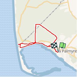

Length
12.3 km

Max alt
28 m

Uphill gradient
84 m
Km-Effort
13.5 km

Min alt
1 m

Downhill gradient
84 m
Boucle
Yes
Creation date :
2019-04-01 20:23:30.765
Updated on :
2019-04-01 20:23:30.805
2h59
Difficulty : Easy

FREE GPS app for hiking
 SityTrail
IGN / Geographical institutes
SityTrail Plus
The world is yours!
About
Trail Walking of 12.3 km to be discovered at New Aquitaine, Charente-Maritime, Les Mathes. This trail is proposed by marcel.F.
Description
boucle marche 12 km
pinède phare de la Coubre
Positioning
Country:
France
Region :
New Aquitaine
Department/Province :
Charente-Maritime
Municipality :
Les Mathes
Location:
Unknown
Start:(Dec)
Start:(UTM)
641147 ; 5061241 (30T) N.
Comments