


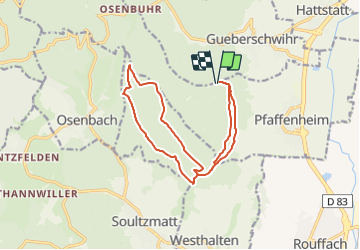
2016 06 04 Cross Schauenberg

staubalex
User

Length
14.6 km

Max alt
584 m

Uphill gradient
382 m
Km-Effort
19.7 km

Min alt
373 m

Downhill gradient
382 m
Boucle
Yes
Creation date :
2016-06-04 00:00:00.0
Updated on :
2016-06-04 00:00:00.0
1h17
Difficulty : Difficult

FREE GPS app for hiking
 SityTrail
IGN / Geographical institutes
SityTrail Plus
The world is yours!
About
Trail Other activity of 14.6 km to be discovered at Grand Est, Haut-Rhin, Pfaffenheim. This trail is proposed by staubalex.
Positioning
Country:
France
Region :
Grand Est
Department/Province :
Haut-Rhin
Municipality :
Pfaffenheim
Location:
Unknown
Start:(Dec)
Start:(UTM)
370478 ; 5317078 (32T) N.
Comments