


col du ROUSSET

Michel07
User
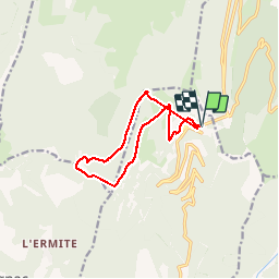

Length
11.6 km

Max alt
1544 m

Uphill gradient
567 m
Km-Effort
19.1 km

Min alt
1201 m

Downhill gradient
567 m
Boucle
Yes
Creation date :
2016-06-12 00:00:00.0
Updated on :
2016-06-12 00:00:00.0
3h15
Difficulty : Medium

FREE GPS app for hiking
 SityTrail
IGN / Geographical institutes
SityTrail Plus
The world is yours!
About
Trail Walking of 11.6 km to be discovered at Auvergne-Rhône-Alpes, Drôme, Chamaloc. This trail is proposed by Michel07.
Photos

Positioning
Country:
France
Region :
Auvergne-Rhône-Alpes
Department/Province :
Drôme
Municipality :
Chamaloc
Location:
Unknown
Start:(Dec)
Start:(UTM)
689499 ; 4967757 (31T) N.
Comments