


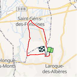
66 LAROQUE DES ALBERES, (maison) à ST GENIS DES FONTAINES , par les Vernédes, ch. du mas Rancoure - Cami de La Creu - Rd2 - Itin.17

jeff66
User


52m
Difficulty : Easy

FREE GPS app for hiking
 SityTrail
IGN / Geographical institutes
SityTrail Plus
The world is yours!
About
Trail Walking of 5.2 km to be discovered at Occitania, Pyrénées-Orientales, Laroque-des-Albères. This trail is proposed by jeff66.
Description
66 LAROQUE DES ALBERES, (maison) à ST GENIS DES FONTAINES , rue de La Chapelle, les Vernédes, ch. du mas Rancoure, rues pasteur- de la république- de l'église, av. du gal Leclercq- des alberes, Cami de la Creu, Cami de Ciuréde, RD2, rues des Vernédes et de La Chapelle - Itin.17
Positioning
Comments