


ciboure Cambo

lolowawa
User
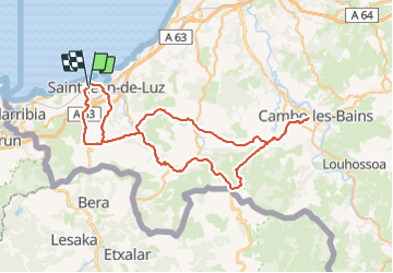

Length
77 km

Max alt
193 m

Uphill gradient
1232 m
Km-Effort
94 km

Min alt
0 m

Downhill gradient
1255 m
Boucle
No
Creation date :
2016-06-24 00:00:00.0
Updated on :
2016-06-24 00:00:00.0
5h18
Difficulty : Medium

FREE GPS app for hiking
 SityTrail
IGN / Geographical institutes
SityTrail Plus
The world is yours!
About
Trail Cycle of 77 km to be discovered at New Aquitaine, Pyrénées-Atlantiques, Ciboure. This trail is proposed by lolowawa.
Description
sortie route alliant tourisme et effort physique
Positioning
Country:
France
Region :
New Aquitaine
Department/Province :
Pyrénées-Atlantiques
Municipality :
Ciboure
Location:
Unknown
Start:(Dec)
Start:(UTM)
606429 ; 4804540 (30T) N.
Comments