


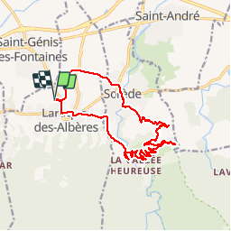
66 BAROQUE DES ALBERES - SOREDE - Vallée Heureuse - ND Du château d'Ultréra - Itin.22

jeff66
User


3h11
Difficulty : Difficult

FREE GPS app for hiking
 SityTrail
IGN / Geographical institutes
SityTrail Plus
The world is yours!
About
Trail Walking of 17.3 km to be discovered at Occitania, Pyrénées-Orientales, Laroque-des-Albères. This trail is proposed by jeff66.
Description
66 BAROQUE DES ALBERES - SOREDE - rues des caroubiers, des Vernédes, de La Chapelle, av. du Roussillon, des écoles, av. des Baléares et de la côte vermeille - mas Rocaries et Manyères - SOREDE - Av. de la vallée heureuse - Valbères - mas del Ca - Vallee des Tortues - pont de la Resclosa résidence St Xavier - rue de la Fargue - piste DFCI AL33 - citerne PE DFCI 375 et 302 - ND Du château d'Ultréra - SOREDE - rue et traverse ND Du château, du mas Tarté, du Veinat, passerelle dont del Sabather, rues des Lilas, du stade, des fabriques, de la Gabarre - mas pages - gué - mas San JULIA - ch. de Tanya - chapelle de Tanya - ROnd point J.Darne - Itin.22
Positioning
Comments