


La Conche

ARPF
User

Length
11 km

Max alt
2077 m

Uphill gradient
597 m
Km-Effort
19 km

Min alt
1469 m

Downhill gradient
596 m
Boucle
Yes
Creation date :
2016-06-27 00:00:00.0
Updated on :
2016-06-27 00:00:00.0
3h51
Difficulty : Unknown

FREE GPS app for hiking
 SityTrail
IGN / Geographical institutes
SityTrail Plus
The world is yours!
About
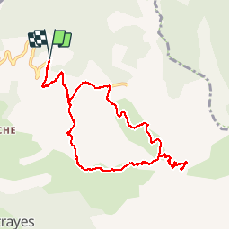
Trail Walking of 11 km to be discovered at Provence-Alpes-Côte d'Azur, Alpes-de-Haute-Provence, Enchastrayes. This trail is proposed by ARPF.
Positioning
Country:
France
Region :
Provence-Alpes-Côte d'Azur
Department/Province :
Alpes-de-Haute-Provence
Municipality :
Enchastrayes
Location:
Unknown
Start:(Dec)
Start:(UTM)
317340 ; 4917672 (32T) N.
Comments

