Trail Walking Stavelot - Water Trek - Le Parcours des Vallées - Etape 5 : Amermont-Coo - Photo

Water Trek - Le Parcours des Vallées - Etape 5 : Amermont-Coo

Randonnées d'Aqualis PRO

© OpenStreetMap contributors
Length
Length
16.6 km
Max alt
Max alt
508 m
Uphill gradient
Uphill gradient
442 m
Km-Effort
Km-Effort  
23 km
Min alt
Min alt
233 m
Downhill gradient
Downhill gradient
635 m
Boucle
Boucle
No
Signpost
Signpost
Creation date :
2018-04-09 13:01:26.668
Updated on :
2018-04-09 13:01:26.668

(0 Reviews)

Walking
Walking
4h47
Difficulty : Difficult

Scan this QR Code to open this trail in the SityTrail application

FREE GPS app for hiking

Logo SityTrail SityTrail

IGN / Geographical institutes

Download SityTrail from the App Store Download SityTrail from Google Play

Logo SityTrail SityTrail World

The world is yours!

Download SityTrail from the App Store Download SityTrail from Google Play Download SityTrail on Huawei AppGallery

About

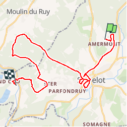
Trail Walking of 16.6 km to be discovered at Wallonia, Liège, Stavelot. This trail is proposed by Aqualis.

Description

Vous quittez la salle d'Amermont pour suivre le RAVeL jusqu'à Stavelot. Petit tour en ville avant l'effort dans la Montagne de l'Ancre. Ensuite les bois jusqu'au point sur Roanne avant de revenir sur Ster. Là-bas, vous allez progresser à travers bois jusqu'au belvédère Thiry avant de redescendre via un sentier sinueux jusqu'à la Cascade de Coo.

Elevation profile

Photos

Points of interest

Point of interest Stavelot -  CAMPING DE L'EAU ROUGE - Photo
Aqualis
Point of interest Stavelot - PLACE ST REMACLE - Photo
Aqualis
Point of interest Stavelot - ABBAYE DE STAVELOT - Photo
Aqualis
Point of interest Stavelot - LES ETANGS - Photo
Aqualis
STAVELOT 
Point of interest Stavelot - OFFICE DU TOURISME - Photo
Aqualis
Point of interest Stavelot - RESTAURANTS - HOTELS - Photo
Aqualis
Point of interest Stavelot - EGLISE ST SEBASTIEN - Photo
Aqualis
Point of interest Stavelot - LE VIEUX STAVELOT - Photo
Aqualis
Point of interest Stavelot - TELESIEGE DE COO - Photo
Aqualis
Point of interest Stavelot - PLOPSACOO - Photo
Aqualis
STAVELOT 
Point of interest Stavelot - LA CASCADE DE COO - Photo
Aqualis
Point of interest Stavelot - CAMPING DE LA CASCADE - Photo
Aqualis

Positioning

Country:
Belgium
Region :
Wallonia
Department/Province :
Liège
Municipality :
Stavelot
Location:
Stavelot
Start:(UTM)
708901 ; 5588575 (31U) N.

Trails nearby

Trail Walking Trois-Ponts - RB-Lg-27_Trois-Ponts - Photo
Walking
PRO

Walking

(7)
Trois-Ponts, Wallonia, Liège, Belgium
23 km | 33 km-effort
7h 30min
Yes
Trail Walking Stavelot - 2021-06-30_12h14m27_stavelot_13km_new - Photo
Walking
GUIDE
mumu.larandonneuse

Walking

Medium
(2)
Stavelot, Wallonia, Liège, Belgium
13.4 km | 19.8 km-effort
4h 30min
Yes
Trail Walking Stavelot - 2021-03-10_14h59m08_1227 - Photo
Walking
GUIDE
mumu.larandonneuse

Walking

Difficult
(3)
Stavelot, Wallonia, Liège, Belgium
18.8 km | 26 km-effort
5h 53min
No
Trail Walking Trois-Ponts - RB-Lg-27_Trois-Ponts_via-racc - Photo
Walking
PRO

Walking

Very difficult
(1)
Trois-Ponts, Wallonia, Liège, Belgium
16.9 km | 25 km-effort
5h 36min
Yes
Trail Walking Stavelot - Francorchamps  - Photo
Walking
motou.bedeur1@gmail.com

Walking

(1)
Stavelot, Wallonia, Liège, Belgium
13.4 km | 18.2 km-effort
3h 56min
Yes
Trail Walking Stavelot - Chemin des Sources |stage 3 STAVELOT - HOCKAI - Photo
Walking
PRO

Walking

Very difficult
(1)
Stavelot, Wallonia, Liège, Belgium
19 km | 25 km-effort
5h 45min
No
Trail On foot Malmedy - Brasserie de Bellevaux - Photo
On foot
PRO

On foot

Easy
(3)
Malmedy, Wallonia, Liège, Belgium
10.2 km | 13.1 km-effort
4h 0min
Yes
Trail Trail Stavelot - Extratrail - Stavelot (red) 23km - Photo
Trail
PRO

Trail

Very difficult
(1)
Stavelot, Wallonia, Liège, Belgium
23 km | 35 km-effort
Unknown
Yes
Trail Trail Stavelot - Extra Trail - Stavelot (blue) 13km - Photo
Trail
PRO

Trail

Difficult
(1)
Stavelot, Wallonia, Liège, Belgium
13.4 km | 19.5 km-effort
Unknown
Yes


Close
My subscriptions