


Graves St Amand 14-07-2016

jmrobin
User
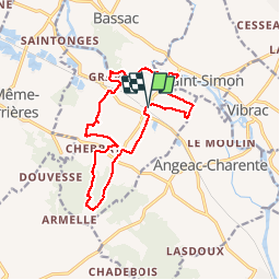

Length
14.6 km

Max alt
101 m

Uphill gradient
149 m
Km-Effort
16.6 km

Min alt
13 m

Downhill gradient
149 m
Boucle
Yes
Creation date :
2019-03-04 10:37:51.369
Updated on :
2019-03-04 10:37:51.403
3h17
Difficulty : Easy

FREE GPS app for hiking
 SityTrail
IGN / Geographical institutes
SityTrail Plus
The world is yours!
About
Trail Walking of 14.6 km to be discovered at New Aquitaine, Charente, Graves-Saint-Amant. This trail is proposed by jmrobin.
Photos

Positioning
Country:
France
Region :
New Aquitaine
Department/Province :
Charente
Municipality :
Graves-Saint-Amant
Location:
Unknown
Start:(Dec)
Start:(UTM)
726433 ; 5058483 (30T) N.
Comments