


trace 16072016

fabwin
User GUIDE
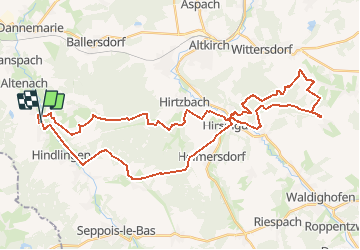

Length
45 km

Max alt
426 m

Uphill gradient
799 m
Km-Effort
55 km

Min alt
307 m

Downhill gradient
809 m
Boucle
Yes
Creation date :
2016-07-16 00:00:00.0
Updated on :
2016-07-16 00:00:00.0
3h00
Difficulty : Medium

FREE GPS app for hiking
 SityTrail
IGN / Geographical institutes
SityTrail Plus
The world is yours!
About
Trail Mountain bike of 45 km to be discovered at Grand Est, Haut-Rhin, Strueth. This trail is proposed by fabwin.
Positioning
Country:
France
Region :
Grand Est
Department/Province :
Haut-Rhin
Municipality :
Strueth
Location:
Unknown
Start:(Dec)
Start:(UTM)
358953 ; 5272151 (32T) N.
Comments