


les lacs de Nohede

ThonyM
User
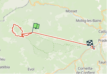

Length
29 km

Max alt
2181 m

Uphill gradient
1740 m
Km-Effort
55 km

Min alt
371 m

Downhill gradient
2521 m
Boucle
No
Creation date :
2016-07-18 00:00:00.0
Updated on :
2016-07-18 00:00:00.0
6h44
Difficulty : Medium

FREE GPS app for hiking
 SityTrail
IGN / Geographical institutes
SityTrail Plus
The world is yours!
About
Trail Walking of 29 km to be discovered at Occitania, Pyrénées-Orientales, Nohèdes. This trail is proposed by ThonyM.
Description
Ca monte pas mal jusqu'au lac. 900m environ
Photos


Positioning
Country:
France
Region :
Occitania
Department/Province :
Pyrénées-Orientales
Municipality :
Nohèdes
Location:
Unknown
Start:(Dec)
Start:(UTM)
439184 ; 4720136 (31T) N.
Comments