


Collet vert (ou grd Collet)

lviallet
User
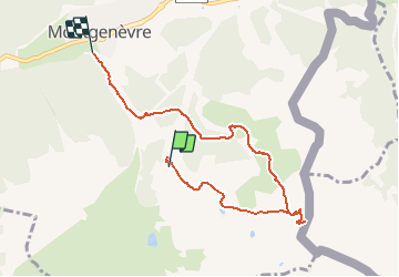

Length
7.1 km

Max alt
2491 m

Uphill gradient
398 m
Km-Effort
13.6 km

Min alt
1825 m

Downhill gradient
755 m
Boucle
No
Creation date :
2016-07-19 00:00:00.0
Updated on :
2016-07-19 00:00:00.0
2h32
Difficulty : Medium

FREE GPS app for hiking
 SityTrail
IGN / Geographical institutes
SityTrail Plus
The world is yours!
About
Trail Walking of 7.1 km to be discovered at Provence-Alpes-Côte d'Azur, Hautes-Alpes, Montgenèvre. This trail is proposed by lviallet.
Positioning
Country:
France
Region :
Provence-Alpes-Côte d'Azur
Department/Province :
Hautes-Alpes
Municipality :
Montgenèvre
Location:
Unknown
Start:(Dec)
Start:(UTM)
320771 ; 4976035 (32T) N.
Comments