


Le chemin du bief Bovet

gilsep
User
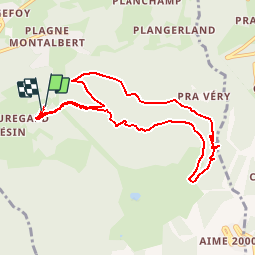

Length
8.9 km

Max alt
1805 m

Uphill gradient
412 m
Km-Effort
14.4 km

Min alt
1485 m

Downhill gradient
411 m
Boucle
Yes
Creation date :
2016-07-26 00:00:00.0
Updated on :
2016-07-26 00:00:00.0
3h15
Difficulty : Medium

FREE GPS app for hiking
 SityTrail
IGN / Geographical institutes
SityTrail Plus
The world is yours!
About
Trail Walking of 8.9 km to be discovered at Auvergne-Rhône-Alpes, Savoy, Aime-la-Plagne. This trail is proposed by gilsep.
Description
Départ du parking du centre de vacances du dou de la Ramaz.
Positioning
Country:
France
Region :
Auvergne-Rhône-Alpes
Department/Province :
Savoy
Municipality :
Aime-la-Plagne
Location:
Aime
Start:(Dec)
Start:(UTM)
315318 ; 5044157 (32T) N.
Comments