


Autour d'Aime

gilsep
User
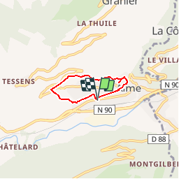

Length
3.7 km

Max alt
824 m

Uphill gradient
160 m
Km-Effort
5.9 km

Min alt
660 m

Downhill gradient
160 m
Boucle
Yes
Creation date :
2016-07-31 00:00:00.0
Updated on :
2016-07-31 00:00:00.0
1h00
Difficulty : Very easy

FREE GPS app for hiking
 SityTrail
IGN / Geographical institutes
SityTrail Plus
The world is yours!
About
Trail Nordic walking of 3.7 km to be discovered at Auvergne-Rhône-Alpes, Savoy, Aime-la-Plagne. This trail is proposed by gilsep.
Description
Départ de la gendarmerie d'Aime.
Positioning
Country:
France
Region :
Auvergne-Rhône-Alpes
Department/Province :
Savoy
Municipality :
Aime-la-Plagne
Location:
Unknown
Start:(Dec)
Start:(UTM)
316156 ; 5047308 (32T) N.
Comments