


Les châteaux de Soultzbach

Claudele
User
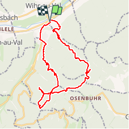

Length
21 km

Max alt
793 m

Uphill gradient
734 m
Km-Effort
30 km

Min alt
304 m

Downhill gradient
734 m
Boucle
Yes
Creation date :
2016-08-03 00:00:00.0
Updated on :
2016-08-03 00:00:00.0
7h21
Difficulty : Difficult

FREE GPS app for hiking
 SityTrail
IGN / Geographical institutes
SityTrail Plus
The world is yours!
About
Trail Walking of 21 km to be discovered at Grand Est, Haut-Rhin, Wihr-au-Val. This trail is proposed by Claudele.
Positioning
Country:
France
Region :
Grand Est
Department/Province :
Haut-Rhin
Municipality :
Wihr-au-Val
Location:
Unknown
Start:(Dec)
Start:(UTM)
366587 ; 5322999 (32U) N.
Comments