


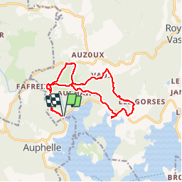
digue d'Auphelle (Vassiviere)

zoe.vienne
User

Length
15 km

Max alt
705 m

Uphill gradient
323 m
Km-Effort
19.3 km

Min alt
610 m

Downhill gradient
323 m
Boucle
Yes
Creation date :
2016-08-08 00:00:00.0
Updated on :
2016-08-08 00:00:00.0
3h45
Difficulty : Medium

FREE GPS app for hiking
 SityTrail
IGN / Geographical institutes
SityTrail Plus
The world is yours!
About
Trail Walking of 15 km to be discovered at New Aquitaine, Creuse, Royère-de-Vassivière. This trail is proposed by zoe.vienne.
Description
Randonnée du 8/08/2016.
Photos
 - Photo 1")
 - Photo 2")
 - Photo 3")
 - Photo 4")
Positioning
Country:
France
Region :
New Aquitaine
Department/Province :
Creuse
Municipality :
Royère-de-Vassivière
Location:
Unknown
Start:(Dec)
Start:(UTM)
410723 ; 5073956 (31T) N.
Comments