


2016 GR5 J2

staubalex
User
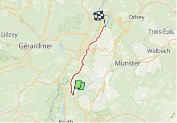

Length
19.4 km

Max alt
1355 m

Uphill gradient
837 m
Km-Effort
30 km

Min alt
1136 m

Downhill gradient
729 m
Boucle
No
Creation date :
2016-08-12 00:00:00.0
Updated on :
2016-08-12 00:00:00.0
6h24
Difficulty : Difficult

FREE GPS app for hiking
 SityTrail
IGN / Geographical institutes
SityTrail Plus
The world is yours!
About
Trail Other activity of 19.4 km to be discovered at Grand Est, Haut-Rhin, Kruth. This trail is proposed by staubalex.
Positioning
Country:
France
Region :
Grand Est
Department/Province :
Haut-Rhin
Municipality :
Kruth
Location:
Unknown
Start:(Dec)
Start:(UTM)
349666 ; 5315909 (32T) N.
Comments