


2016 GR5 J0

staubalex
User
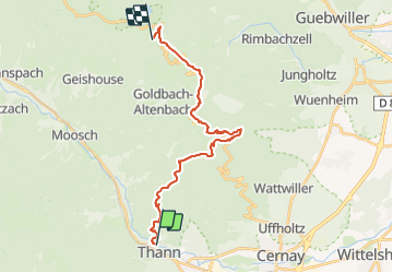

Length
23 km

Max alt
1409 m

Uphill gradient
1612 m
Km-Effort
41 km

Min alt
340 m

Downhill gradient
550 m
Boucle
No
Creation date :
2016-08-12 00:00:00.0
Updated on :
2016-08-12 00:00:00.0
9h02
Difficulty : Very difficult

FREE GPS app for hiking
 SityTrail
IGN / Geographical institutes
SityTrail Plus
The world is yours!
About
Trail Other activity of 23 km to be discovered at Grand Est, Haut-Rhin, Thann. This trail is proposed by staubalex.
Positioning
Country:
France
Region :
Grand Est
Department/Province :
Haut-Rhin
Municipality :
Thann
Location:
Unknown
Start:(Dec)
Start:(UTM)
357850 ; 5297268 (32T) N.
Comments