


Molkenrain

Derrendinger
User

Length
27 km

Max alt
1120 m

Uphill gradient
958 m
Km-Effort
40 km

Min alt
300 m

Downhill gradient
958 m
Boucle
Yes
Creation date :
2017-03-19 00:00:00.0
Updated on :
2017-03-19 00:00:00.0
2h33
Difficulty : Medium

FREE GPS app for hiking
 SityTrail
IGN / Geographical institutes
SityTrail Plus
The world is yours!
About
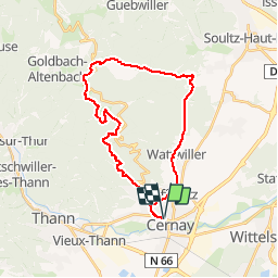
Trail Mountain bike of 27 km to be discovered at Grand Est, Haut-Rhin, Cernay. This trail is proposed by Derrendinger.
Description
descente sur Wuenheim
Positioning
Country:
France
Region :
Grand Est
Department/Province :
Haut-Rhin
Municipality :
Cernay
Location:
Unknown
Start:(Dec)
Start:(UTM)
363196 ; 5296798 (32T) N.
Comments