Trail Running Pampelonne - Raid des 3 Lacs Trail 2016 - Photo

Raid des 3 Lacs Trail 2016

 J-Mi
J-Mi

User

© OpenStreetMap contributors
Length
Length
10.5 km
Max alt
Max alt
492 m
Uphill gradient
Uphill gradient
503 m
Km-Effort
Km-Effort  
17.2 km
Min alt
Min alt
270 m
Downhill gradient
Downhill gradient
497 m
Boucle
Boucle
Yes
Creation date :
2016-08-25 00:00:00.0
Updated on :
2016-08-25 00:00:00.0

(1 Reviews)

Running
Running
1h28
Difficulty : Difficult

Scan this QR Code to open this trail in the SityTrail application

FREE GPS app for hiking

Logo SityTrail SityTrail

IGN / Geographical institutes

Download SityTrail from the App Store Download SityTrail from Google Play

Logo SityTrail SityTrail World

The world is yours!

Download SityTrail from the App Store Download SityTrail from Google Play Download SityTrail on Huawei AppGallery

About

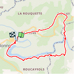
Trail Running of 10.5 km to be discovered at Occitania, Tarn, Pampelonne. This trail is proposed by J-Mi.

Description

12 KM trace technique

Elevation profile

Positioning

Country:
France
Region :
Occitania
Department/Province :
Tarn
Municipality :
Pampelonne
Location:
Unknown
Start:(UTM)
440496 ; 4886105 (31T) N.

Comments

Please log in to post a review or rate the element


Trails nearby

Trail Walking Tanus - Tanus le Vieux vers la chapelle de Las Planques - Photo
Walking
tercla

Walking

Medium
Tanus, Occitania, Tarn, France
10 km | 16 km-effort
3h 24min
Yes
Trail On foot Tanus - Sentier de Pays des Gorges du Viaur - Photo
On foot
PRO

On foot

Very difficult
Tanus, Occitania, Tarn, France
65 km | 93 km-effort
21h 10min
No
Trail On foot Pampelonne - Ciruit du Château de Thuriès et du Viaur - Photo
On foot
PRO

On foot

Easy
Pampelonne, Occitania, Tarn, France
6.5 km | 9.2 km-effort
2h 5min
No
Trail On foot Sainte-Gemme - Les Farguettes  - Photo
On foot
tercla

On foot

Easy
Sainte-Gemme, Occitania, Tarn, France
10.4 km | 14.1 km-effort
3h 12min
No
Trail Walking Pampelonne - sentier des crètes - Photo
Walking
christian425

Walking

Difficult
(1)
Pampelonne, Occitania, Tarn, France
11.6 km | 16.6 km-effort
4h 28min
Yes
Trail Running Tanus - Vallée du Viaur et Chapelle de las planques - Photo
Running
tophe73

Running

Medium
Tanus, Occitania, Tarn, France
8.9 km | 13.3 km-effort
1h 7min
No
Trail Walking Tauriac-de-Naucelle - pont de tanus - Photo
Walking
prof_physique

Walking

Very easy
(1)
Tauriac-de-Naucelle, Occitania, Aveyron, France
9.3 km | 14.8 km-effort
Unknown
Yes
Trail Walking Pampelonne - Fontbonne  autour du barrage - Photo
Walking
tercla

Walking

Very easy
Pampelonne, Occitania, Tarn, France
8.3 km | 11.3 km-effort
2h 9min
Yes
Trail Walking Pampelonne - chemin des crêtes - Photo
Walking
jpipacific

Walking

Medium
Pampelonne, Occitania, Tarn, France
11.7 km | 16.6 km-effort
3h 52min
Yes


Close
My subscriptions