


2016 toussaint j2

Airelle
User
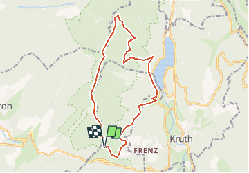

Length
14.6 km

Max alt
1202 m

Uphill gradient
944 m
Km-Effort
27 km

Min alt
519 m

Downhill gradient
920 m
Boucle
Yes
Creation date :
2016-10-17 00:00:00.0
Updated on :
2016-10-17 00:00:00.0
3h50
Difficulty : Unknown

FREE GPS app for hiking
 SityTrail
IGN / Geographical institutes
SityTrail Plus
The world is yours!
About
Trail Walking of 14.6 km to be discovered at Grand Est, Haut-Rhin, Fellering. This trail is proposed by Airelle.
Positioning
Country:
France
Region :
Grand Est
Department/Province :
Haut-Rhin
Municipality :
Fellering
Location:
Unknown
Start:(Dec)
Start:(UTM)
345110 ; 5310345 (32T) N.
Comments