


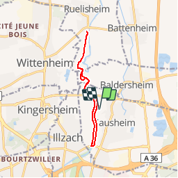
Ill de Sausheim à Ruelisheim

patrickbeyrath
User

Length
10.7 km

Max alt
233 m

Uphill gradient
54 m
Km-Effort
11.4 km

Min alt
219 m

Downhill gradient
54 m
Boucle
Yes
Creation date :
2018-10-13 05:52:22.449
Updated on :
2018-10-13 05:52:22.456
2h32
Difficulty : Very easy

FREE GPS app for hiking
 SityTrail
IGN / Geographical institutes
SityTrail Plus
The world is yours!
About
Trail Walking of 10.7 km to be discovered at Grand Est, Haut-Rhin, Sausheim. This trail is proposed by patrickbeyrath.
Positioning
Country:
France
Region :
Grand Est
Department/Province :
Haut-Rhin
Municipality :
Sausheim
Location:
Unknown
Start:(Dec)
Start:(UTM)
377521 ; 5294518 (32T) N.
Comments
un peu difficile à s'approprier la mise en oeuvre du logiciel au début. Je suis néophyte dans le genre je pense qu' apres ququ temps ça ira mieux.
Je débute avec Sity donc à fur et à mesure que je m'améliorerai je donnerai mon avis. À bientôt
f