


Rompach Le Franc

LaurentGILG
User
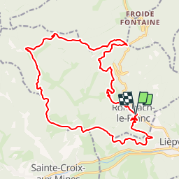

Length
21 km

Max alt
743 m

Uphill gradient
844 m
Km-Effort
32 km

Min alt
298 m

Downhill gradient
845 m
Boucle
Yes
Creation date :
2019-01-20 20:50:28.623
Updated on :
2019-01-20 20:50:28.63
6h49
Difficulty : Very difficult

FREE GPS app for hiking
 SityTrail
IGN / Geographical institutes
SityTrail Plus
The world is yours!
About
Trail Walking of 21 km to be discovered at Grand Est, Haut-Rhin, Rombach-le-Franc. This trail is proposed by LaurentGILG.
Positioning
Country:
France
Region :
Grand Est
Department/Province :
Haut-Rhin
Municipality :
Rombach-le-Franc
Location:
Unknown
Start:(Dec)
Start:(UTM)
371233 ; 5349118 (32U) N.
Comments