


angles sur l'anglin

olivieraron
User
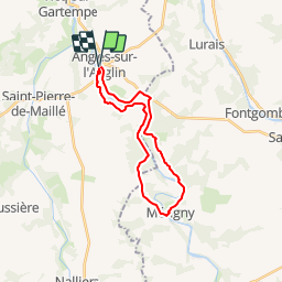

Length
22 km

Max alt
123 m

Uphill gradient
309 m
Km-Effort
26 km

Min alt
67 m

Downhill gradient
306 m
Boucle
Yes
Creation date :
2019-01-14 09:44:16.049
Updated on :
2019-01-14 09:44:17.361
7m
Difficulty : Unknown

FREE GPS app for hiking
 SityTrail
IGN / Geographical institutes
SityTrail Plus
The world is yours!
About
Trail Other activity of 22 km to be discovered at New Aquitaine, Vienne, Angles-sur-l'Anglin. This trail is proposed by olivieraron.
Positioning
Country:
France
Region :
New Aquitaine
Department/Province :
Vienne
Municipality :
Angles-sur-l'Anglin
Location:
Unknown
Start:(Dec)
Start:(UTM)
338072 ; 5173340 (31T) N.
Comments