Trail Walking Elne - Circuit touristique Elne - Photo

Circuit touristique Elne

 bernarb
bernarb

User

© OpenStreetMap contributors
Length
Length
3 km
Max alt
Max alt
40 m
Uphill gradient
Uphill gradient
38 m
Km-Effort
Km-Effort  
3.5 km
Min alt
Min alt
14 m
Downhill gradient
Downhill gradient
38 m
Boucle
Boucle
Yes
Creation date :
2016-10-08 00:00:00.0
Updated on :
2016-10-08 00:00:00.0

(0 Reviews)

Walking
Walking
49m
Difficulty : Unknown

Scan this QR Code to open this trail in the SityTrail application

FREE GPS app for hiking

Logo SityTrail SityTrail

IGN / Geographical institutes

Download SityTrail from the App Store Download SityTrail from Google Play

Logo SityTrail SityTrail World

The world is yours!

Download SityTrail from the App Store Download SityTrail from Google Play Download SityTrail on Huawei AppGallery

About

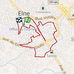
Trail Walking of 3 km to be discovered at Occitania, Pyrénées-Orientales, Elne. This trail is proposed by bernarb.

Description

Départ du parking San Jordi face à l'Office du Tourisme.
Visite du Cloître et de la cathédrale à ne pas manquer si vous aimez l'histoire.
Octobre 2016

Elevation profile

Photos

Positioning

Country:
France
Region :
Occitania
Department/Province :
Pyrénées-Orientales
Municipality :
Elne
Location:
Unknown
Start:(UTM)
497564 ; 4716412 (31T) N.

Trails nearby

Trail Walking Théza - 66 THEZA - CORNEILLA-DEL-VERCOL - Photo
Walking
jeff66

Walking

Easy
(2)
Théza, Occitania, Pyrénées-Orientales, France
7 km | 7.5 km-effort
1h 8min
Yes
Trail Walking Saint-Cyprien - SAINT-CYPRIEN 66 - front de mer - les CAPELLANS - Photo
Walking
jeff66

Walking

Easy
(2)
Saint-Cyprien, Occitania, Pyrénées-Orientales, France
9.9 km | 10.3 km-effort
2h 11min
Yes
Trail Equestrian Saint-Cyprien - bocal du Tech - Photo
Equestrian
sandymocko

Equestrian

Medium
(1)
Saint-Cyprien, Occitania, Pyrénées-Orientales, France
17 km | 17.7 km-effort
3h 20min
Yes
Trail Walking Saint-André - 66 SAINT-ANDRE à PALAU-DEL-VIDRE, canal de Palau, le fort, Villeclare, itinéraire partagé - Photo
Walking
jeff66

Walking

Easy
(1)
Saint-André, Occitania, Pyrénées-Orientales, France
5.7 km | 6.2 km-effort
1h 2min
Yes
Trail Walking Ortaffa - 20240229 Ortoffa-Banuyls-des-Aspres-Brouillas - Photo
Walking
ThonyM

Walking

Medium
Ortaffa, Occitania, Pyrénées-Orientales, France
19 km | 21 km-effort
4h 20min
Yes
Trail Walking Corneilla-del-Vercol - thématique mo tescot du 18 02 2023 - Photo
Walking
66Gribouille83

Walking

Medium
(1)
Corneilla-del-Vercol, Occitania, Pyrénées-Orientales, France
8.9 km | 9.4 km-effort
1h 57min
Yes
Trail Walking Argelès-sur-Mer - 66 TAXO D'AVALL, voie piétonne de TAXO À LA MER, ARGELES-PLAGE puis ARGELES SUR MER - Photo
Walking
jeff66

Walking

Medium
Argelès-sur-Mer, Occitania, Pyrénées-Orientales, France
8.4 km | 9 km-effort
1h 18min
Yes
Trail Walking Saint-Cyprien - 66 SAINT-CYPRIEN - ALENYA - LATOUR-BAS-ELNE - de berges en berges  - Photo
Walking
jeff66

Walking

Medium
Saint-Cyprien, Occitania, Pyrénées-Orientales, France
7.9 km | 8.3 km-effort
1h 16min
Yes
Trail Walking Palau-del-Vidre - 66 PALAU-DEL-VIDRE - promenade dans les rues du village, point d'eau Sant Marti et retour par les champs - Photo
Walking
jeff66

Walking

Easy
Palau-del-Vidre, Occitania, Pyrénées-Orientales, France
6.6 km | 7 km-effort
1h 8min
Yes


Close
My subscriptions