Trail Walking Ceillac - Lac Miroir - lac des Rouites - Lac Ste Anne - Photo

Lac Miroir - lac des Rouites - Lac Ste Anne

 R@ph
R@ph

User GUIDE

© OpenStreetMap contributors
Length
Length
16.1 km
Max alt
Max alt
2413 m
Uphill gradient
Uphill gradient
980 m
Km-Effort
Km-Effort  
29 km
Min alt
Min alt
1679 m
Downhill gradient
Downhill gradient
981 m
Boucle
Boucle
Yes
Creation date :
2016-11-06 00:00:00.0
Updated on :
2016-11-06 00:00:00.0

(0 Reviews)

Walking
Walking
5h53
Difficulty : Difficult

Scan this QR Code to open this trail in the SityTrail application

FREE GPS app for hiking

Logo SityTrail SityTrail

IGN / Geographical institutes

Download SityTrail from the App Store Download SityTrail from Google Play

Logo SityTrail SityTrail World

The world is yours!

Download SityTrail from the App Store Download SityTrail from Google Play Download SityTrail on Huawei AppGallery

About

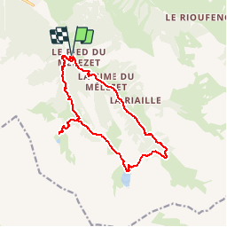
Trail Walking of 16.1 km to be discovered at Provence-Alpes-Côte d'Azur, Hautes-Alpes, Ceillac. This trail is proposed by R@ph.

Description

Nous étions 9 ce jour pour cette randonnée qui vous propose au départ du Mélezet une ascension vers le lac miroir, puis un aller retour vers le lac des Rouites. De très belles couleurs d'automne et les premiers mélèzes dorés. Nous continuerons en direction du lac Ste Anne ou nous ferons la pause casse croute près de la chapelle. Certains jouerons même les lézards avec ce beau soleil et cette magnifique vue. Il nous faut maintenant redescendre par le fond de Chaurionde pour rejoindre la voiture.

Elevation profile

Positioning

Country:
France
Region :
Provence-Alpes-Côte d'Azur
Department/Province :
Hautes-Alpes
Municipality :
Ceillac
Location:
Unknown
Start:(UTM)
324822 ; 4946574 (32T) N.

Trails nearby

Trail Walking Ceillac - Crêtes de Chambrettes - Photo
Walking
GUIDE
amiral13

Walking

Medium
(1)
Ceillac, Provence-Alpes-Côte d'Azur, Hautes-Alpes, France
13.4 km | 26 km-effort
5h 53min
Yes
Trail Walking Ceillac - 05 Tour Font Sancte - étape 1 - Photo
Walking
Maryma

Walking

Very difficult
(1)
Ceillac, Provence-Alpes-Côte d'Azur, Hautes-Alpes, France
16.5 km | 36 km-effort
8h 9min
No
Trail Walking Ceillac - Queyras_lac de Clausis - Photo
Walking
MartinBraudThierry

Walking

Very easy
(1)
Ceillac, Provence-Alpes-Côte d'Azur, Hautes-Alpes, France
13.1 km | 26 km-effort
2h 59min
Yes
Trail Walking Ceillac - Ceillac - St Véran - Photo
Walking
GUIDE
romanceline

Walking

Medium
Ceillac, Provence-Alpes-Côte d'Azur, Hautes-Alpes, France
13.5 km | 28 km-effort
7h 22min
No
Trail Walking Ceillac - le Longet ou tête du Rissace - Photo
Walking
GUIDE
amiral13

Walking

Medium
Ceillac, Provence-Alpes-Côte d'Azur, Hautes-Alpes, France
13 km | 25 km-effort
6h 26min
Yes
Trail Walking Ceillac - la pointe de la Saume (traversée) - Photo
Walking
GUIDE
amiral13

Walking

Difficult
Ceillac, Provence-Alpes-Côte d'Azur, Hautes-Alpes, France
15 km | 34 km-effort
6h 43min
No
Trail Walking Ceillac - Lac Ste Anne et Tête de Girardin - Photo
Walking
GUIDE
amiral13

Walking

Medium
Ceillac, Provence-Alpes-Côte d'Azur, Hautes-Alpes, France
14.4 km | 27 km-effort
5h 48min
Yes
Trail Walking Ceillac - lac Sainte Anne - Photo
Walking
griffet

Walking

Easy
(2)
Ceillac, Provence-Alpes-Côte d'Azur, Hautes-Alpes, France
10.7 km | 17.9 km-effort
5h 16min
No
Trail Walking Ceillac - #1 Queyras 3j étape 1 Ceillac - Lac de Roue - Photo
Walking
Liobric

Walking

Very difficult
Ceillac, Provence-Alpes-Côte d'Azur, Hautes-Alpes, France
16.7 km | 33 km-effort
7h 34min
No


Close
My subscriptions