


saint quentin

bert16
User
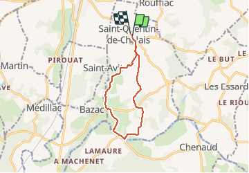

Length
10.7 km

Max alt
109 m

Uphill gradient
181 m
Km-Effort
13.2 km

Min alt
27 m

Downhill gradient
193 m
Boucle
Yes
Creation date :
2016-12-06 00:00:00.0
Updated on :
2016-12-06 00:00:00.0
2h50
Difficulty : Medium

FREE GPS app for hiking
 SityTrail
IGN / Geographical institutes
SityTrail Plus
The world is yours!
About
Trail Walking of 10.7 km to be discovered at New Aquitaine, Charente, Saint-Quentin-de-Chalais. This trail is proposed by bert16.
Positioning
Country:
France
Region :
New Aquitaine
Department/Province :
Charente
Municipality :
Saint-Quentin-de-Chalais
Location:
Unknown
Start:(Dec)
Start:(UTM)
270056 ; 5015675 (31T) N.
Comments