


gerrandosantémenhir

LouisROGER
User GUIDE
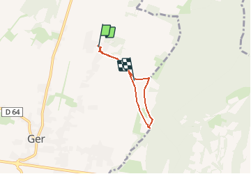

Length
5.6 km

Max alt
402 m

Uphill gradient
57 m
Km-Effort
6.4 km

Min alt
370 m

Downhill gradient
57 m
Boucle
No
Creation date :
2016-11-20 00:00:00.0
Updated on :
2016-11-20 00:00:00.0
1h24
Difficulty : Unknown

FREE GPS app for hiking
 SityTrail
IGN / Geographical institutes
SityTrail Plus
The world is yours!
About
Trail Walking of 5.6 km to be discovered at New Aquitaine, Pyrénées-Atlantiques, Ger. This trail is proposed by LouisROGER.
Description
promenade Rando Santé


Positioning
Country:
France
Region :
New Aquitaine
Department/Province :
Pyrénées-Atlantiques
Municipality :
Ger
Location:
Unknown
Start:(Dec)
Start:(UTM)
740458 ; 4794960 (30T) N.
Comments