


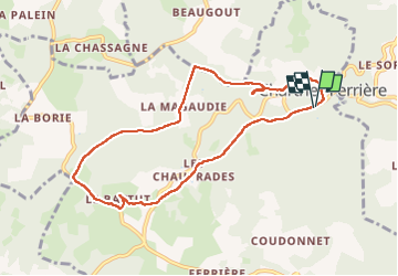
Chartrier-Ferrière

houbart
User

Length
8.7 km

Max alt
319 m

Uphill gradient
133 m
Km-Effort
10.5 km

Min alt
255 m

Downhill gradient
135 m
Boucle
Yes
Creation date :
2019-03-28 15:47:17.234
Updated on :
2023-04-02 14:26:15.983
2h18
Difficulty : Unknown

FREE GPS app for hiking
 SityTrail
IGN / Geographical institutes
SityTrail Plus
The world is yours!
About
Trail Walking of 8.7 km to be discovered at New Aquitaine, Corrèze, Chartrier-Ferrière. This trail is proposed by houbart.
Positioning
Country:
France
Region :
New Aquitaine
Department/Province :
Corrèze
Municipality :
Chartrier-Ferrière
Location:
Unknown
Start:(Dec)
Start:(UTM)
378068 ; 4991786 (31T) N.
Comments