


Phare de Chassiron

dmatignon
User

Length
9.8 km

Max alt
12 m

Uphill gradient
45 m
Km-Effort
10.4 km

Min alt
0 m

Downhill gradient
45 m
Boucle
Yes
Creation date :
2017-06-05 00:00:00.0
Updated on :
2017-06-05 00:00:00.0
2h00
Difficulty : Medium

FREE GPS app for hiking
 SityTrail
IGN / Geographical institutes
SityTrail Plus
The world is yours!
About
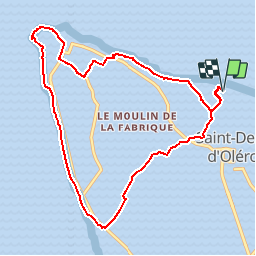
Trail Nordic walking of 9.8 km to be discovered at New Aquitaine, Charente-Maritime, Saint-Denis-d'Oléron. This trail is proposed by dmatignon.
Description
Boucle de marche nordique au départ du parking face au camping de la plage de Soubregeon à Saint Denis d'Oléron (campagne, falaises, vignes, ...).
Positioning
Country:
France
Region :
New Aquitaine
Department/Province :
Charente-Maritime
Municipality :
Saint-Denis-d'Oléron
Location:
Unknown
Start:(Dec)
Start:(UTM)
625360 ; 5099791 (30T) N.
Comments